Nebraska
Nebraska Weather Alert Tornado Risk Then Record‑Breaking Heat Wave Approaches
From midweek severe storms with tornado potential to scorching weekend temperatures, here’s your must‑read Nebraska forecast.
| 84°64° | Some sun, then clouds, not as hot; heavy t-storms in the afternoon; storms can bring flooding downpours, hail, damaging wind gusts, and an isolated tornado | |
| 83°63° | Partly sunny and humid with a couple of showers and a thunderstorm; a big warmup is on the way later this week | |
| 95°71° | Warmer with plenty of sunshine | |
| 103°75° | Windy and very hot with blazing sunshine; caution advised if outside for extended periods of time | |
| 102°75° | Blazing sunshine, windy and very hot; caution advised if outside for extended periods of time | |
| 98°76° | Sunny, windy and hot; possible danger of dehydration and heatstroke while doing strenuous activities | |
| 95°74° | Very warm with sunshine |
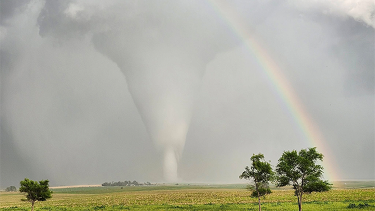
Nebraska is in for a weather rollercoaster this week, swinging from severe thunderstorms and tornado threats to an intense heat wave topping 100°F by the weekend. Stay informed and stay prepared.
🌩️ Early‑Week Storm Threats
Tuesday brings scattered afternoon and evening storms across Omaha and eastern Nebraska. Be on alert: these storms may unleash heavy rain, hail, damaging 60+ mph winds, and even isolated tornadoes—severe weather risk is elevated. The National Weather Service has declared “First Alert” status for Tuesday late, warning residents to secure outdoor items and have a shelter plan ready.
☀️ Midweek Transition
Wednesday offers a brief reprieve: humid but generally calmer with scattered showers and less severe weather—perfect for catching your breath—but summer heat is building behind the scenes .
🔥 Weekend Heat Wave
From Thursday onward, temperatures will surge. Omaha is forecasted to leap into the mid‑90s Thursday, with a record‑breaking 103°F on Friday and 102°F Saturday, accompanied by gusty winds from the south. Sunday and Monday continue hot, but storms may return with a chance of isolated afternoon activity. Heat indices could reach dangerous levels.


Nebraska
A scorching heat dome is coming: Triple-digit temperatures and ‘record-shattering’ highs set to roast millions
From DC to Florida and up to New York, over 15 million face dangerous heat as oppressive humidity pushes the ‘feels like’ temp to 110°F — and there’s more to come.
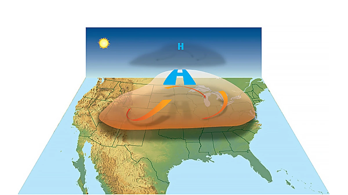
Summer is about to crank up the misery dial for millions across the eastern half of the United States. A punishing heat dome — one of the most potent in recent years — is gearing up to send temperatures soaring into the triple digits, shattering daily records and pushing power grids to the brink.
More than 15 million people from the Washington, DC, region down to parts of Florida are under a level 3-of-4 major heat risk through Thursday, according to the National Weather Service. This heat doesn’t discriminate — it’s dangerous for anyone without reliable cooling or enough water to stay hydrated.
And it’s only the beginning.
This first wave of suffocating heat is being driven by a stubborn high-pressure system over the western Atlantic, sucking hot, moisture-laden air from the Caribbean into the U.S. That tropical origin means heat that doesn’t just scorch — it sticks, bringing sky-high humidity that makes nights unbearable and days feel even hotter than the thermometer shows.
While the worst of Thursday’s blast will bake Virginia and the Carolinas, parts of the Northeast and central U.S. will also sweat through an early taste of what forecasters warn is a more expansive and intense heat dome setting up for next week.
By the weekend, this dome will stretch its grip from the southern Plains to the Midwest, the Mid-Atlantic and deep into the Northeast. High temperatures across these regions are forecast to jump 15 degrees above normal, marking the hottest stretch of the year so far. Factor in humidity, and it could feel like 110°F — especially in cities like DC, New York and St. Louis.
By the weekend, this dome will stretch its grip from the southern Plains to the Midwest, the Mid-Atlantic and deep into the Northeast. High temperatures across these regions are forecast to jump 15 degrees above normal, marking the hottest stretch of the year so far. Factor in humidity, and it could feel like 110°F — especially in cities like DC, New York and St. Louis.
A level 4-of-4 extreme heat risk — the highest alert — is already on the radar for early next week. Cities including Chicago, New York City, Washington, DC and St. Louis could bake under unrelenting, long-duration heat with little overnight relief.
It’s not just an uncomfortable inconvenience: public health experts say this level of sustained heat can be deadly, especially for seniors, young children and anyone working outdoors.
Record books will feel the heat too:
- Denver could hit a daily record of 101°F on Friday.
- Chicago is bracing for back-to-back highs of 95°F Saturday and 96°F Sunday.
- New York City may flirt with daily records Monday and Tuesday, with highs of 95°F and 96°F — just shy of historic marks from the early 1900s.
- Washington, DC could push to a scorching 100°F, a rare June milestone that would rewrite local records.
- Even Boston isn’t safe: highs of 92°F and 94°F are forecast early next week.
Altogether, forecasters warn that over 150 daily temperature records could topple between Monday and Tuesday, including both record highs and record warm nighttime lows.
Experts urge everyone to check on neighbors, limit time outdoors, drink plenty of water and find cool shelter when possible. This heat dome is relentless — and it’s not leaving anytime soon.
Nebraska
Broken trees, 7,000 lightning strikes and 60 mph winds: Stormy night leaves thousands in the dark across central NC
A WRAL Weather Alert Day turned into a rough Thursday evening as severe storms toppled trees, cut power and lit up the night sky over central North Carolina.
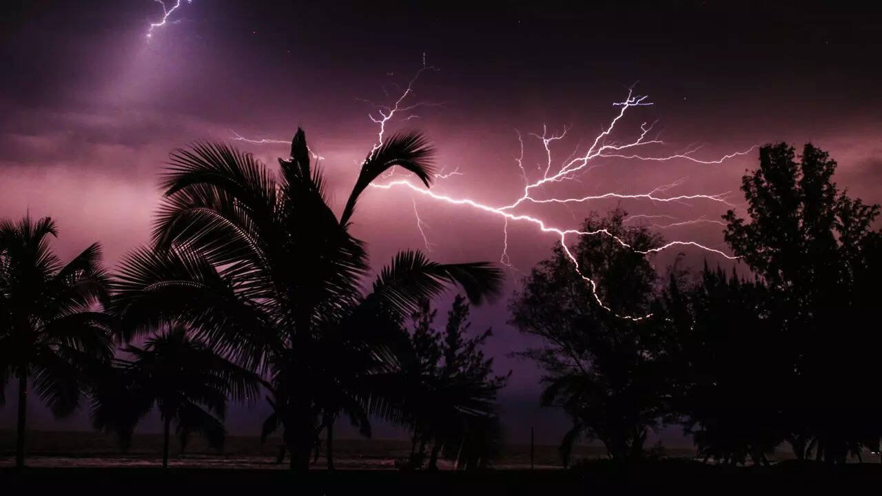
A calm Thursday afternoon quickly turned chaotic across central North Carolina as a fierce line of storms, riding a sharp cold front, unleashed heavy rain, fierce wind gusts and a dazzling — and dangerous — display of lightning.
WRAL meteorologists had declared it a WRAL Weather Alert Day, warning residents of possible 60 mph wind gusts and periods of torrential downpours. By sunset, those warnings turned into reality.
Between 8 p.m. and 11 p.m., multiple severe thunderstorm warnings rippled across the state. Counties like Vance and Wake bore the brunt, with WRAL News receiving dozens of reports of downed trees — including one blocking traffic on Blenheim Drive in Raleigh.
Residents described the storms as fast-moving and aggressive, with intense bursts of lightning crackling across neighborhoods. According to the National Weather Service, the storms produced more than 7,000 lightning strikes across the region — enough to light up the night sky and test the patience of local emergency crews.
But it wasn’t just trees and roads taking the hit. Power grids struggled under the assault of falling limbs and gusting winds. In Durham, more than 13,000 Duke Energy customers found themselves in the dark at the peak of the outages. Crews scrambled overnight to restore power and clear debris as more scattered showers lingered into the early hours.
Meteorologists say the storms formed along a potent cold front clashing with warm, unstable air, a classic setup for North Carolina’s summer storm season.
Residents are urged to stay alert for more pop-up storms in the coming days as the pattern remains unsettled — and to keep extra batteries handy just in case Mother Nature has more surprises in store.

“She’s too easy to beat”—Claressa Shields defends undisputed crown and dares Laila Ali to accept $15M mega-fight offer

“Rest Easy Pawpaw” Swamp People legend Junior Edwards dies and fans say he’s running hoop nets in heaven

Who is this masked man Arsenal fans erupt as €63M star Gyökeres unveiled before late Ødegaard penalty stuns Newcastle

Lamine Yamal wears No. 10 as Barcelona crush Vissel Kobe 3-1 in preseason thriller—Here’s what stole the show…

She was crying and calling her family Michigan Walmart stabbing leaves 11 injured, 6 critical in shocking random attack

Donald Trump’s net worth reveals the fortune behind the former US President and business mogul

Caitlin Clark Sidelined with Quad Strain, Set to Miss Two Weeks of WNBA Action

Elon Musk Breaks Ranks with Trump Over ‘Big, Beautiful’ Tax Bill

Golden Glory: Team USA Wins First Standalone Ice Hockey World Championship in 91 Years

Eduardo Nunez and Masanori Rikiishi Make Weight, Set Stage for Explosive IBF Title Showdown in Yokohama

7 Powerful Lines from Jessica Simpson’s Fade Song That Reveal the Truth Behind Her Breakup

Emma Watson Banned From Driving After Speeding Offences Shock Fans in 2025

Swag or Surprise Justin Bieber’s Mysterious New Album Drops Friday With Gunna Sexyy Red, and Cash Cobain — But That’s Not All

Bosch spinoff ‘Ballard’ drops on Prime Video: Why Maggie Q’s cold case cop is nothing like you’ve seen before…

Cardi B deletes Stefon Diggs from Instagram just weeks after going official — ‘I’m gonna be outside with a partner…’ but who?
-

 World News4 days ago
1-Iran Issues Dire Warning to Israel and Defies Trump on Nukes: “We’re Ready to Strike Deep Inside”
-

 Weather3 days ago
Gilbert Weather Forecast Turns Volatile Heat Advisory and Storm Watch Issued
-

 Sports7 days ago
Ricky Ponting once said “I learned from the best” but who were Australia’s 5 greatest cricketers ever?
-

 Entertainment4 days ago
Ozzy Osbourne dies at 76 after final concert with Black Sabbath fans say It finally caught up with him…
-

 Cricket1 week ago
Top 5 Fastest Bowlers in Cricket History Who Delivered Blazing Thunderbolts that Shocked the World
-

 Entertainment1 week ago
Coldplay CEO Scandal Shocks Tech World as Viral Jumbotron Clip Forces Astronomer Chief on Leave and Sparks 7 Unbelievable Reactions
-

 Sports1 week ago
Andre Russell Drops Bombshell Hint at Retirement from International Cricket — What’s Next for the T20 Fearless Titan?
-
 Entertainment4 days ago
7 Powerful Lines from Jessica Simpson’s Fade Song That Reveal the Truth Behind Her Breakup