New Mexico
New Mexico Brace for Scorching Heat Fire Threat and Weekend Storm Relief

| 97°66° | Hot with plenty of sun; breezy this afternoon; gusty winds, low humidity and dry brush result in a high fire threat | |
| 96°69° | Plenty of sunshine | |
| 98°70° | Partly sunny and hot; danger of dehydration and heatstroke if outside for extended periods of time | |
| 97°71° | Mostly sunny and hot; breezy in the afternoon; possible danger of dehydration and heatstroke while doing strenuous activities | |
| 98°70° | Hazy sunshine and hot; breezy in the afternoon; possible danger of dehydration and heatstroke while doing strenuous activities | |
| 93°66° | Intervals of clouds and sunshine; breezy in the afternoon | |
| 86°65° | Not as hot with times of clouds and sun; an afternoon thunderstorm or two |
New Mexicans, get ready—your week is set to sizzle before the skies cool down. Here’s what to keep in mind for Albuquerque, Santa Fe, Roswell, and beyond.
🔥 Early & Midweek Heat Wave
Expect sun-drenched days with highs in the mid-to-upper 90s°F, tipping into triple digits in places like Roswell and Las Cruces by Wednesday, when heat index values will make it feel well over 100°F. With gusty winds sweeping across the region, the National Weather Service has issued Red Flag Warnings, highlighting the risk of lightning-sparked wildfires paired with dangerously low humidity.
Health experts emphasize that even temperatures in the 90s°F can overwhelm the body, particularly with overnight temps staying in the mid-60s°F or higher. Those without cooling options, outdoor workers, and at-risk communities should prepare early.
🌡️ Heat Peak and Fire Risk
By Thursday and Friday, the heat remains stubbornly high, with similar highs and persistent dryness. Concerns rise over heat-related illnesses such as heat exhaustion and heat stroke, prompting repeated advisories to hydrate, stay cool, and avoid strenuous midday activities . Outdoor burning is discouraged during this peak, and communities are urged to have wildfire response plans ready.
🌧️ Weekend Monsoon Relief
The forecast shifts as the weekend approaches: moisture returns as the North American Monsoon begins to flow into the state. Saturday and Sunday bring hazy sunshine and increasing humidity; by Monday, scattered afternoon showers and possibly thunderstorms will follow highs in the 80s°F . This pattern could offer welcome cooling—and a reprieve from fire danger—though storm-related downpours and lightning means caution remains necessary.


Oaxaca
Erick makes history: Category 3 hurricane slams Mexico’s coast with 125 mph winds — “Warnings fill us with fear…”
Hurricane Erick, the earliest major storm ever to hit Mexico, unleashes destructive winds and torrential rain as residents relive painful memories of Hurricane Otis.
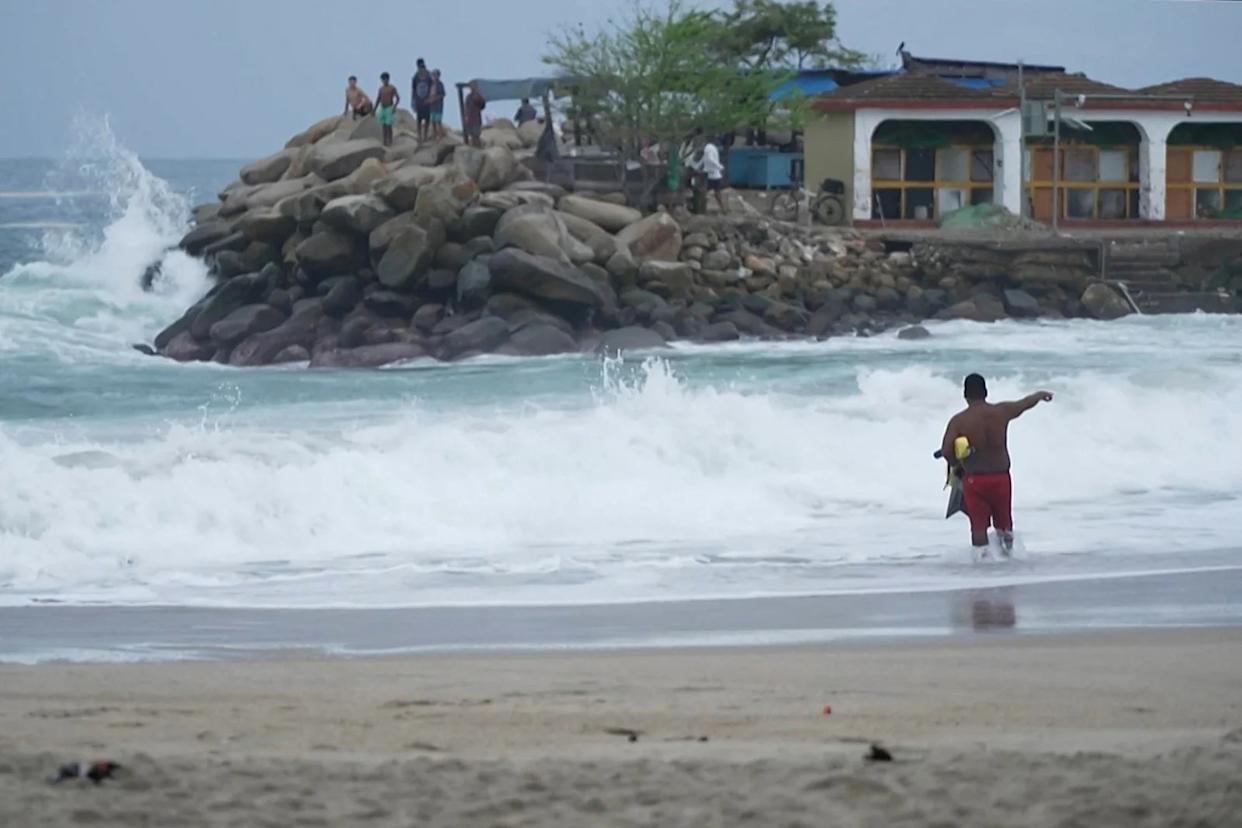
Hurricane Erick carved its name into Mexico’s weather history early Thursday, striking Oaxaca state as a ferocious Category 3 hurricane — the strongest storm ever recorded to hit the country so early in the year.
Roaring ashore with winds of 125 mph, Erick made landfall about 20 miles east of Punta Maldonado just after 6 a.m. CDT, pummeling coastal communities already bracing for days under a deluge. The storm’s power comes less than a year after Hurricane Otis shocked Mexico as a Category 5 monster in nearby Acapulco.
“This is the first time a major hurricane has hit Mexico before July,” the National Hurricane Center confirmed, adding that Erick briefly reached Category 4 strength overnight with terrifying 145 mph winds just off the Pacific coast.
What’s more alarming is how quickly Erick turned vicious: it exploded from a tropical storm to a Category 4 hurricane in just 24 hours — a phenomenon known as rapid intensification, now more common as climate change warms ocean waters.
President Claudia Sheinbaum urged residents to stay indoors and heed emergency instructions as heavy rains and dangerous winds lashed Guerrero and Oaxaca. “Authorities’ warnings fill us with fear,” said Carlos Ozuna Romero, an Acapulco local who lost his beachside restaurant to Otis and was once again stacking chairs and boarding up windows.
Though Erick is expected to weaken rapidly while crawling over Mexico’s rugged mountains, it remains a flood threat of the highest order. The National Hurricane Center warns of life-threatening flooding and mudslides, with up to 16 inches of rain possible in Guerrero’s mountain zones and up to 8 inches across coastal Oaxaca and Guerrero.
Acapulco — still scarred from Otis — narrowly avoided Erick’s strongest winds but will still feel tropical storm-force gusts up to 45 mph and could see up to 6 inches of rain, enough to trigger flash floods and landslides in an already fragile landscape.
More than 580 shelters were prepared across Guerrero, and schools in the state shut down until further notice. Meanwhile, emergency crews raced against time on Wednesday night, clearing drainage canals and cutting back brush to prevent clogged waterways from turning roads into rivers.
The East Pacific hurricane season, which officially began in mid-May, is off to a record-breaking start. Erick is already the fifth named storm and the second hurricane — milestones typically not seen until mid-July. Meanwhile, the Atlantic basin remains eerily quiet, with no storms forecast in the coming days.
As Erick’s remnants drench southern Mexico through Friday, memories of Otis and the fury of nature remain raw for many. For people like Ozuna Romero, every storm warning is more than just a forecast — it’s a painful reminder of what can be lost in a single night.

In Roob’s Stats Bonus Edition Eagles’ Defense Delivers One of the Most Dominant Performances in Franchise History

Patrick Mahomes Suffers ACL Tear as Chiefs Miss Playoffs, Broncos Beat Packers and Bills Ignite AFC East Race

Vikings’ JJ McCarthy Throws for Two Scores, Runs for One to Crush Cowboys’ Playoff Hopes

Hollywood Director Rob Reiner and Wife Michele Found Dead as Homicide Probe Begins

Did Rob Reiner Really Call Donald Trump “Mentally Unfit” to Be President Here’s the Full Truth

1-Iran Issues Dire Warning to Israel and Defies Trump on Nukes: “We’re Ready to Strike Deep Inside”

Donald Trump’s net worth reveals the fortune behind the former US President and business mogul

Caitlin Clark Sidelined with Quad Strain, Set to Miss Two Weeks of WNBA Action

Elon Musk Breaks Ranks with Trump Over ‘Big, Beautiful’ Tax Bill

Golden Glory: Team USA Wins First Standalone Ice Hockey World Championship in 91 Years

Miss Jamaica Suffers Terrifying Fall Off Miss Universe Stage; Rushed to Hospital on Stretcher in Viral Video

Moana Live-Action Teaser Sparks Outrage as Fans Call Disney’s Move a ‘Clear Money Grab’ — What Went Wrong?

Ryan Gosling’s Project Hail Mary Trailer Stuns Fans with a Mysterious Alien Ally and a Mission That Could Save Earth

Apple delays Jessica Chastain thriller The Savant about domestic extremism after recent US violence

Avatar 3, Fire and Ash trailer reveals Jake Sully’s family facing terrifying new Na’vi enemies with deadly fire powers
-

 US News1 week ago
“She Never Made It Out…” Albany House Fire Claims Woman’s Life as Family Pleads for Help to Bring Her Home
-

 Entertainment7 days ago
XG Star Cocona Shares a Brave Truth at 20 — “I Was Born Female, But That Label Never Represented Who I Truly Am…”
-

 Entertainment7 days ago
Samba Schutte Reveals the Surprise Cameo in Pluribus That “Nobody Saw Coming”… and Why John Cena Was Perfect for the Role
-

 Tech1 week ago
After Losing Over $70 Billion, Mark Zuckerberg Finally Admits His Biggest Bet Is “Not Working” – Meta Plans Massive Cuts to Metaverse Budget
-

 Entertainment1 week ago
Nika & Madison stuns global audiences as director Eva Thomas reveals why “resilience, not fear, drives Indigenous women on the run”
-

 Entertainment5 days ago
Saudi Arabia’s entertainment revolution… Red Sea Film Foundation CEO Faisal Baltyuor says he ‘wears many hats’ — but one mission drives them all
-

 Sports5 days ago
Dodgers Stun MLB With Blockbuster Move, Sign Elite Closer Edwin Díaz to Three-Year, $69 Million Deal
-

 Entertainment5 days ago
Teyana Taylor wakes up to a Golden Globe call at 5 a.m.… ‘Am I dreaming right now?’ — and why she’s already begging Paul Thomas Anderson for more