Weather & Environment
Brace Yourself: 3 Regions in NSW & Queensland Face Giant Hail and 125 km/h Gusts from Intense Storms
Severe weather warnings issued as communities from Brisbane to Sydney prepare for hailstones, flooding and power disruptions — here’s what to know.

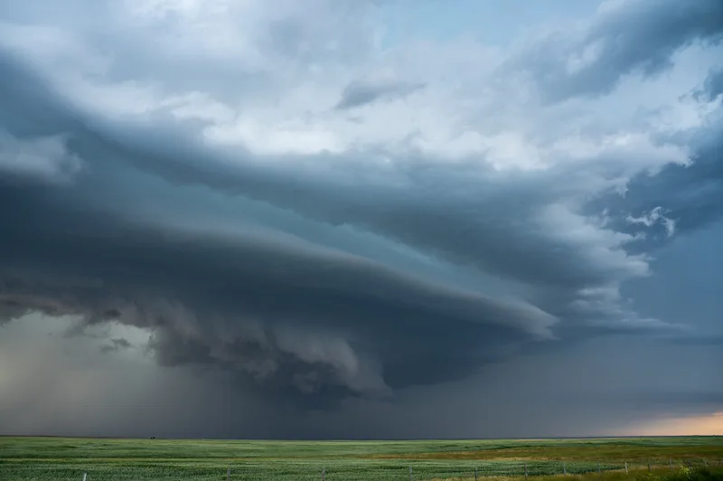
The east coast of Australia is on high alert. The Bureau of Meteorology (BoM) has issued a severe thunderstorm warning for large parts of New South Wales (NSW) and Queensland, cautioning residents that “giant-sized hail” — hailstones measuring more than 5 cm in diameter — could batter vehicles, properties and power infrastructure.
Meteorologist Sarah Scully warned the most intense thunderstorms are expected along the mid-north coast of NSW, the Hunter region and the adjacent ranges. She said:
“It is worth noting that giant sized hail is possible … and that is hail with a diameter of greater than five centimeters.”
The warning covers a zone stretching from south-east Queensland (including the Brisbane area) down through to the Sydney region in NSW. The trigger: a “really strong” cold front coupled with a low-pressure system sweeping across south-east Australia, creating potent instability.
What to expect
- In the alert regions, winds are forecast to reach damaging gusts of 90 km/h+, and in some pockets possibly up to 125 km/h.

- Hail: While 2 cm+ hail is already hazardous, the standout threat is for stones 5 cm or larger — classed as “giant” and capable of shattering windows, denting cars, and tearing up roofs.
- Flash flooding: With heavy rain driven by thunderstorm downdrafts, roads may submerge quickly and visibility will plummet.
- Power outages: With strong winds and hail piling onto trees and power-lines, communities are being told to be ready for blackout scenarios.
Scully explained, “The community impacts could include damage to vehicles and property … as well as travel disruptions and delays due to hazardous driving conditions with water across roads and highways.”
Regions under greatest threat
- The mid-north coast of NSW stands out as the highest-risk area for the largest hail and strongest gusts.
- The Hunter region and surrounding ranges are also flagged for severe storm likelihood.
- The Sydney to Brisbane corridor is under watch, though forecasters believe the storms there are likely to be somewhat less extreme than the regions further north.
BoM’s public update emphasises that while Brisbane and Sydney will see storms, the middle-coast and inland ranges of NSW may bear the brunt.
Timing & duration
The major storm window is Saturday. According to the BoM:
- The worst of the weather should ease by Sunday, though lighter thunderstorms remain possible in northern NSW and south-east Queensland.
- On Sunday, a “much calmer day” is expected though wet and cold conditions will still prevail across parts of NSW.
- For cities such as Melbourne, Canberra, Hobart and Adelaide — the direct storm risk is lower, though rain and cool temperatures loom.

What you can do — practical prep
- Secure outdoor items: High winds can hurl objects into cars or windows.
- Park vehicles under cover or away from trees: Large hail can dent roofs and smash glass.
- Avoid travel during the peak storm window: Roads may become impassable or visibility nil.
- Have a power-outage kit: Torch, batteries, phone charger, water and essentials.
- Monitor official updates: Trust the BoM alerts, local emergency services and broadcast channels.
Why the system is so volatile
The current set-up is a textbook recipe for severe storms: a cold front (bringing a sharp temperature difference) interacting with a strong low-pressure system. That promotes rapid vertical motion (updrafts), large hail-forming hailstones, and vigorous downdrafts which lead to gusty winds. Meteorologists point to such systems as capable of producing isolated but very intense storm cells — meaning one suburb may be hammered, while another barely sees anything.
Looking ahead
While the weekend may bring relief, the burst of extreme weather raises longer-term questions. Experts say Australians must be prepared for increasingly unpredictable events — hail storms, damaging winds and flash flooding may become more common as climate systems shift. The BoM website outlines how severe weather risk is evolving across Australia.
For now, though, the message is clear: Saturday is the day to act. If you live in the mid-north coast of NSW, the Hunter region or the Brisbane-Sydney corridor, think ahead and stay safe.
Visit our site for more news: www.DailyGlobalDiary.com
Weather
Pea-sized hailstorm, gusty winds and funnel clouds? Mecosta & Isabella brace for a stormy Tuesday night…
Pea-sized hailstorm, gusty winds and funnel clouds? Mecosta & Isabella brace for a stormy Tuesday night… National Weather Service issues alert as thunderstorms sweep across Michigan counties—experts warn of weak funnel clouds and 40 mph wind gusts
A severe thunderstorm alert from the National Weather Service (NWS) has turned a quiet Tuesday evening into a night of weather anxiety for Mecosta County and Isabella County in Michigan, with a potent mix of pea-sized hail, gusty winds, and even the potential for funnel clouds.
The warning, issued at 9:29 p.m. EDT on June 24, 2025, is expected to remain active until 10:30 p.m. EDT. According to NWS radar data, a strong thunderstorm was tracked 7 miles southwest of Lake Isabella—moving east at 20 mph—just minutes before the alert went public.
Gusty winds could knock down tree limbs and blow around unsecured objects. Minor damage to outdoor objects is possible, the alert states.
Residents of Mount Pleasant, Shepherd, Lake Isabella, Remus, Millbrook, Winn, and Blanchard are within the impact zone, with winds that could peak at 40 mph and hail measuring 0.25 inches in diameter.
What’s especially concerning is the favorable environment for weak, brief funnel clouds. While not as dangerous as full-blown tornadoes, these phenomena can still pack a punch if not taken seriously. The NWS advises anyone spotting such a cloud to immediately seek shelter indoors and report sightings.
Why You Should Take Lightning Seriously
The United States experiences nearly 25 million lightning strikes annually, and according to the NWS, around 20 people lose their lives to these strikes every year. The risk peaks during active thunderstorms, even when the storm appears to be moving away.
To stay safe:
- Have a lightning safety plan if you’re outdoors.
- If you hear thunder, that’s your cue to find shelter.
- Stay indoors for at least 30 minutes after the last clap of thunder.
- Avoid electrical appliances, plumbing fixtures, and even cord phones during a storm.
- If indoors isn’t an option, stay away from open fields, hilltops, tall trees, water bodies, and metal objects.
According to the Centers for Disease Control and Prevention (CDC), the safest place during a lightning storm is a fully enclosed building or a metal-topped vehicle.
Driving in Downpours? Here’s What You Must Know
Driving through heavy rain poses another major risk. Flood-prone roads, poor visibility, and slippery surfaces can turn your commute into a nightmare.
Expert Tips from the NWS:
- Avoid drainage ditches and culverts, where water flow intensifies rapidly.
- Maintain a safe following distance—double the usual space.
- Slow down and let your vehicle naturally reduce speed.
- Stick to middle lanes to reduce hydroplaning risk.
- Turn on your headlights, even in daylight, to improve visibility.
- Watch for large vehicles, whose tire spray can blind you momentarily.
- During the first 30 minutes of rainfall, roads are most slippery due to oil and grime.
- If visibility is lost, pull over safely and wait it out.
When stopping is necessary, position your vehicle far from moving traffic, ideally beyond guardrails, and activate your emergency lights.
What’s Coming Next?
Weather watchers are keeping a close eye on this storm system. With recent alerts warning of isolated tornadoes and damaging winds across Northern Michigan, including the Traverse City region, it’s clear this pattern is far from over.
Conditions are evolving fast. Even pea-sized hail and 40 mph gusts can disrupt life if you’re not prepared, a local emergency planner told Daily Global Diary.
As always, stay updated via the National Weather Service, keep your emergency kits ready, and avoid risky travel if storms intensify.
Weather & Environment
Tragedy in the Snow: Arizona Couple Found Dead Near Ash Fork — Sheriff’s Office Suspects ‘Exposure’
Bodies of Richard and Elizabeth Alexander lay hidden under heavy snow for days as authorities piece together what really happened near Old Route 66.

In a heartbreaking discovery near Ash Fork, Arizona, a married couple — 74-year-old Richard Alexander and 79-year-old Elizabeth Alexander — were found dead last Friday, their bodies concealed beneath a thick blanket of snow along a rural road near their home.
According to the Yavapai County Sheriff’s Office, initial reports suggest that “exposure” may have played a tragic role in their deaths. Investigators found the couple’s car abandoned along the historic Old Route 66, not far from where their lifeless bodies were eventually uncovered. Officials believe that the heavy snowfall after Thanksgiving may have delayed the discovery, keeping them hidden for an unknown period.

A meteorologist with the National Weather Service confirmed that the Ash Fork area was hit with approximately 12 inches of snow during a powerful winter storm over the holiday weekend, creating hazardous conditions for residents in the remote community.
While the Yavapai County Medical Examiner will provide the final confirmation on the cause of death, deputies say there are no immediate signs of foul play. “Right now, all indications point toward accidental exposure,” an official told local media, adding that extreme weather often poses hidden dangers for elderly residents living in rural Arizona.
Neighbors in the tight-knit Ash Fork community are shaken by the loss, describing the Alexanders as a friendly, loving couple who kept to themselves but were always kind. “It’s just so sad — they were good people,” said a longtime neighbor. “I wish someone had found them sooner.”

Authorities continue to investigate the timeline of events leading up to the tragedy, including when the couple last left their home and why their vehicle was stranded on the rural road.
Residents are urged to stay vigilant during winter storms and to check in on elderly neighbors, especially when severe weather strikes. “This heartbreaking incident is a reminder of how quickly nature can turn deadly,” the Sheriff’s Office emphasized in a public advisory.
The Alexanders’ family has asked for privacy as they grieve and await the final autopsy results.

In Roob’s Stats Bonus Edition Eagles’ Defense Delivers One of the Most Dominant Performances in Franchise History

Patrick Mahomes Suffers ACL Tear as Chiefs Miss Playoffs, Broncos Beat Packers and Bills Ignite AFC East Race

Vikings’ JJ McCarthy Throws for Two Scores, Runs for One to Crush Cowboys’ Playoff Hopes

Hollywood Director Rob Reiner and Wife Michele Found Dead as Homicide Probe Begins

Did Rob Reiner Really Call Donald Trump “Mentally Unfit” to Be President Here’s the Full Truth

1-Iran Issues Dire Warning to Israel and Defies Trump on Nukes: “We’re Ready to Strike Deep Inside”

Donald Trump’s net worth reveals the fortune behind the former US President and business mogul

Caitlin Clark Sidelined with Quad Strain, Set to Miss Two Weeks of WNBA Action

Elon Musk Breaks Ranks with Trump Over ‘Big, Beautiful’ Tax Bill

Golden Glory: Team USA Wins First Standalone Ice Hockey World Championship in 91 Years

Miss Jamaica Suffers Terrifying Fall Off Miss Universe Stage; Rushed to Hospital on Stretcher in Viral Video

Moana Live-Action Teaser Sparks Outrage as Fans Call Disney’s Move a ‘Clear Money Grab’ — What Went Wrong?

Ryan Gosling’s Project Hail Mary Trailer Stuns Fans with a Mysterious Alien Ally and a Mission That Could Save Earth

Apple delays Jessica Chastain thriller The Savant about domestic extremism after recent US violence

Avatar 3, Fire and Ash trailer reveals Jake Sully’s family facing terrifying new Na’vi enemies with deadly fire powers
-

 US News1 week ago
“She Never Made It Out…” Albany House Fire Claims Woman’s Life as Family Pleads for Help to Bring Her Home
-

 Entertainment7 days ago
XG Star Cocona Shares a Brave Truth at 20 — “I Was Born Female, But That Label Never Represented Who I Truly Am…”
-

 Entertainment7 days ago
Samba Schutte Reveals the Surprise Cameo in Pluribus That “Nobody Saw Coming”… and Why John Cena Was Perfect for the Role
-

 Entertainment1 week ago
Nika & Madison stuns global audiences as director Eva Thomas reveals why “resilience, not fear, drives Indigenous women on the run”
-

 Tech1 week ago
After Losing Over $70 Billion, Mark Zuckerberg Finally Admits His Biggest Bet Is “Not Working” – Meta Plans Massive Cuts to Metaverse Budget
-

 Entertainment5 days ago
Saudi Arabia’s entertainment revolution… Red Sea Film Foundation CEO Faisal Baltyuor says he ‘wears many hats’ — but one mission drives them all
-

 Sports5 days ago
Dodgers Stun MLB With Blockbuster Move, Sign Elite Closer Edwin Díaz to Three-Year, $69 Million Deal
-

 Entertainment5 days ago
Teyana Taylor wakes up to a Golden Globe call at 5 a.m.… ‘Am I dreaming right now?’ — and why she’s already begging Paul Thomas Anderson for more