Emergencies & Disaster
Mount Lewotobi Laki-Laki Eruption Triggers Flight Chaos. Virgin Australia Cancels Bali Routes… Here’s What’s Happening
An explosive eruption in Indonesia has grounded major international flights, sent ash 18 km into the sky, and left thousands stranded — experts warn more disruptions may follow.
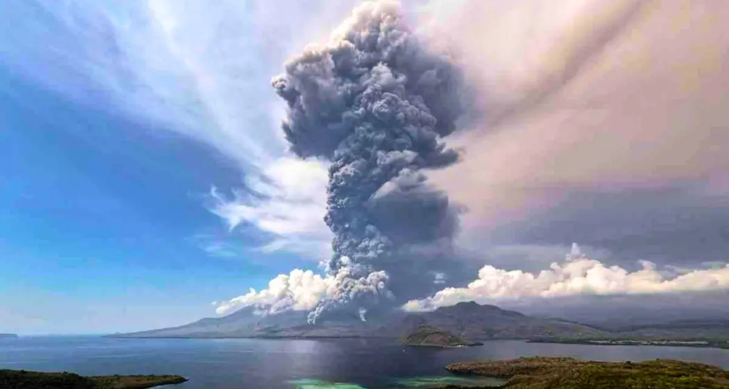
In a dramatic display of nature’s fury, Mount Lewotobi Laki-Laki — one of Indonesia’s most volatile volcanoes — erupted again this week, sending a tower of ash soaring 18 kilometers into the atmosphere and triggering widespread travel chaos across the Asia-Pacific region. The eruption marks the second major volcanic outburst in as many months and has once again brought the spotlight back to Indonesia’s volatile geological underbelly.
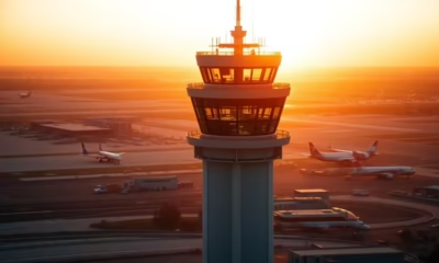
The fallout was swift. By Monday afternoon, at least five international flights between Australia and Bali were grounded, with several more delayed. Carriers including Virgin Australia, Qantas, and Jetstar scrambled to adjust schedules as volcanic ash threatened aircraft safety and visibility.
“The Safety of Our Guests Is Our Highest Priority”
A spokesperson for Virgin Australia confirmed that multiple Bali services had been cancelled. “We regret the impact of this on guests’ travel plans and encourage all travelers to closely monitor their flight status,” they said. Jetstar echoed a similar sentiment, stating that “several flights between Bali and Australia have been cancelled this evening” and impacted customers have been offered alternative options.
Meanwhile, Qantas Airways confirmed that flights QF43 from Sydney and QF45 from Melbourne were delayed, with safety teams “closely monitoring the movement of volcanic ash.”
The Perth Airport website also listed the cancellation of Bali-bound Jetstar flights JQ106 and JQ116. However, Ngurah Rai International Airport in Bali continues to operate normally — for now.
A Volcanic Giant Awakens Again
The eruption, according to Indonesia’s Geological Agency and the MAGMA Indonesia agency, unleashed a torrent of hot gas, lava, and ash clouds as far as five kilometers down the slopes. Drone footage confirmed that the crater had filled with lava, and volcanic tremors indicated magma movement deep within the earth’s crust.
Geology Agency chief Muhammad Wafid, speaking during a seminar in Switzerland, warned that the eruption had reached a severity not seen since November 2024, when Mount Lewotobi last killed nine people and injured dozens more. “An eruption of that size certainly carries a higher potential for danger, including its impact on aviation,” he said.
As a result, the volcano’s alert level was raised to the maximum, with authorities doubling the exclusion zone to a 7-kilometer radius. Residents and tourists have been ordered to stay clear of the zone, and masks were recommended to protect from ash inhalation.
Lahar Floods and Aviation Hazards Loom
Beyond the towering ash clouds, authorities are bracing for lahar floods — dangerous flows of volcanic debris that can turn rivers into lethal torrents during rainfall. These are especially concerning for the densely populated Flores region, where rivers run close to villages and tourist zones.
While no casualties have been reported in the most recent eruption, concerns remain about ongoing seismic activity. “This is not just a one-time explosion,” Wafid emphasized. “We are observing continuous tremors and rising pressure inside the volcano.”
Flashback to a Pattern of Destruction
Mount Lewotobi Laki-Laki’s reawakening follows a series of eruptions over the past year. In November 2024, its eruption led to nine deaths and forced mass evacuations. In March, it erupted again, followed by another major burst in June, which prompted mass flight cancellations and airspace warnings.
The mountain, standing at 1,584 meters, is a twin volcano paired with Mount Lewotobi Perempuan in Flores Timur district. It’s among the 120 active volcanoes across Indonesia — a country that straddles the Pacific Ring of Fire, a seismically active zone notorious for earthquakes and volcanic eruptions.
Tourists Left Stranded, Airlines Brace for More Disruptions
Tourists and travelers in both Australia and Indonesia were left in limbo as airlines issued advisories and travel alerts. Some vacationers described chaotic scenes at departure gates, with announcements of cancellations made minutes before scheduled boarding.
“This was supposed to be our honeymoon trip to Bali,” said a traveler from Melbourne stranded at Perth Airport. “We were so excited… now we don’t even know if we’ll be able to fly this week.”
The ripple effects are being felt by other international carriers as well. Last month’s eruption affected flights operated by Singapore Airlines, Air India, and Air New Zealand, and the current eruption is expected to cause a similar impact.
What’s Next?
With the ash cloud still hovering and seismic activity ongoing, experts warn that further flight cancellations, airport disruptions, and even emergency evacuations may become necessary.
Volcanologist Dr. Retno Ningsih warned in a televised interview that “this type of continuous activity may indicate the volcano is entering a new eruptive phase.” She urged for “strong coordination between aviation authorities and geological agencies” to ensure passenger safety.
Australian airlines have not yet issued updates for Wednesday schedules, but internal sources suggest contingency plans are already being prepared, depending on the trajectory of the ash cloud and weather conditions.
For now, residents of Flores Island and nearby communities are being asked to remain on alert — and so are the airlines.


Emergencies & Disaster
4.7 Earthquake Rattles Western Australia in Dead of Night but What Locals Said After Might Shock You”
A shallow 4.7 magnitude earthquake hit near Merredin, WA early Wednesday morning—residents report shaking beds and strange underground sounds.

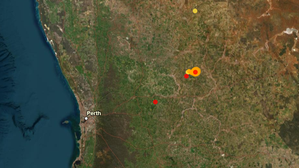
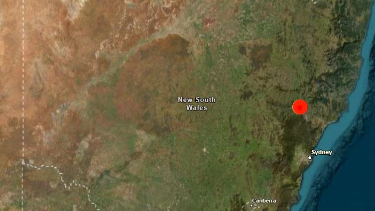
In the early hours of Wednesday, Western Australia experienced an unsettling tremor—a moderate magnitude 4.7 earthquake struck near the small town of Merredin, jolting residents from sleep and setting social media abuzz.
Table of Contents
According to Geoscience Australia, the quake occurred at approximately 2:01 AM local time on July 30th, 2025. While the magnitude of 4.7 might not seem extraordinary in seismic terms, what makes this event especially notable is the depth—or lack thereof. The tremor originated just 3.3 miles (5.3 km) beneath the Earth’s surface, making it a very shallow earthquake, which often results in stronger ground shaking than deeper quakes.
Shallow quakes tend to release more energy close to the surface, and that was certainly the case here. While there have been no confirmed reports of major structural damage, tremors were widely felt across the Wheatbelt Region, and some minor damage was reported in nearby communities.
Eyewitness Reactions: “Like a Truck Hit My House”
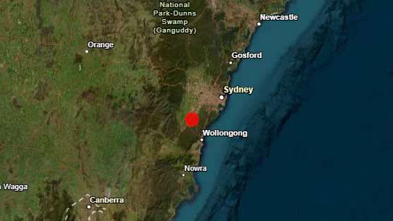
“I thought a truck crashed into the building,” said a startled resident of South Yelbeni, a town of just 29 people located barely a mile from the quake’s epicenter. The ground reportedly shook violently for nearly 10 seconds, enough to rattle shelves, swing ceiling fans, and wake nearly everyone in town.
In North Tammin, around 15 miles away, residents described the sensation as a “long rolling shake” rather than a sudden jolt. This kind of feedback is critical to seismic monitoring networks like VolcanoDiscovery, which urges people to report their experiences for real-time data aggregation.
Cities That Felt the Tremor
Though the earthquake was centered near South Yelbeni, its effects rippled outward across much of Western Australia. Here’s how some towns experienced it:
- Wyalkatchem (17 miles away, population 400): Weak shaking
- Kellerberrin (24 miles away, population 960): Light to weak shaking
- Merredin (40 miles away, population 2,900): Light shaking
- Northam (62 miles away, population 6,500): Very weak shaking
- York, Beverley, and Toodyay (all 65–72 miles away): Barely noticeable or very weak tremors
This broad geographical impact underlines how even moderate quakes can be felt over long distances when the seismic energy is released so close to the surface.
Why This Quake Matters
While Western Australia is not known for frequent seismic activity, events like this highlight the region’s complex geology. According to experts at Geoscience Australia, the quake likely occurred along an ancient fault line within the Yilgarn Craton, a stable but fractured geological structure underlying much of the state.
Seismologist Dr. Rachel Forster of the University of Western Australia noted, “The depth of this quake is what made it so noticeable. While it didn’t reach damaging levels, it’s a reminder that even in regions we consider geologically ‘quiet,’ the Earth is still moving beneath us.”
Preparedness and Community Response
Emergency services were quick to respond, though fortunately, no rescues were necessary. The State Emergency Service (SES) issued a statement asking residents to check their homes for any signs of structural compromise—particularly cracked walls, chimneys, or underground pipes.
“We encourage all residents to secure heavy furniture and have a basic emergency plan in place,” said an SES spokesperson. The advice echoes broader preparedness campaigns run by the Australian Government and organizations like the Red Cross.
Did You Feel It?
One of the most crucial tools in earthquake science today is crowd-sourced data. Both Geoscience Australia and VolcanoDiscovery urge people in affected areas to report their experience, no matter how mild. This input helps fine-tune scientific models, which can better predict future risks and help urban planners prepare infrastructure accordingly.
A Region on Alert
Although the quake was not followed by any noticeable aftershocks, seismologists remain on alert. “It’s not unusual for a quake like this to have a series of smaller aftershocks, sometimes days or even weeks later,” said Dr. Forster.
At present, there’s no indication of increased seismic risk, but that could change if any aftershocks follow.
Human Curiosity and the Earth Beneath Us
As we’ve seen time and again—from Turkey to Japan—earthquakes are a part of nature’s language. They remind us that the Earth’s crust is a dynamic, ever-changing system. Even in the relatively stable interior of Australia, ancient geological tensions can erupt with surprising power.
Whether you’re in a big city like Perth, or a tiny town like South Yelbeni, staying informed and prepared remains the best response. And when the Earth speaks—like it did this Wednesday morning—it’s up to us to listen and learn.
for more news visit www.DailyGlobalDiary.com
World
Japan rocked by 1000+ quakes in 2 weeks as viral manga ‘prophecy’ fuels panic… Govt says “don’t believe comic books”
From evacuations in Kagoshima to flight cancellations from Hong Kong, Japan faces real tremors and viral rumors after a 1999 manga ‘predicts’ a megaquake—government urges calm and science.
In a country no stranger to seismic activity, Japan is battling not just tremors from the earth—but a tidal wave of fear driven by an unlikely source: a manga comic book.
Over 1,000 earthquakes have rocked the Kagoshima Prefecture in the past two weeks, prompting emergency evacuations, media frenzy, and even international travel cancellations. The most powerful so far, a magnitude 5.5 earthquake that struck last Thursday, left residents reeling and authorities scrambling to calm growing fears.
“With our current scientific knowledge, it’s difficult to predict the exact time, place or scale of an earthquake,” said Ayataka Ebita, director of the Japan Meteorological Agency’s earthquake and tsunami monitoring division, in a press briefing following Saturday’s 5.4 magnitude tremor.
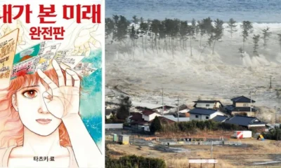
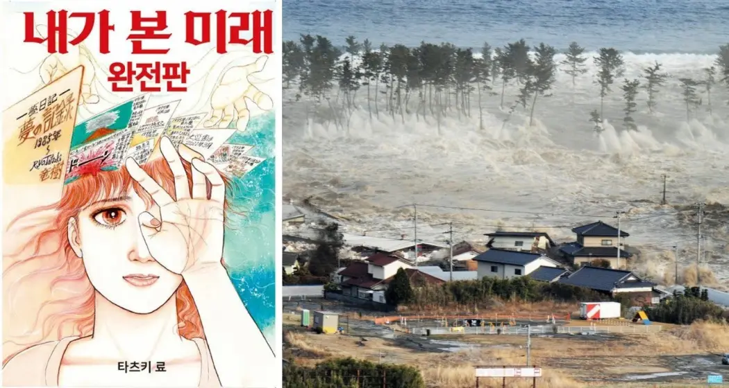
But while the quakes are real, panic has been amplified by something else entirely: a Japanese manga from the 1990s that some believe predicted a devastating quake for this very month.
What’s fueling the fear? A 1999 comic book
At the heart of the hysteria is Ryo Tatsuki’s manga “The Future I Saw”, first published in 1999 and re-released in 2021. The comic includes a panel that allegedly forecasts a catastrophic event in July 2025. Though the manga is clearly labeled as fiction, its eerie coincidence with the recent seismic uptick has led to widespread speculation.
“I’m not a prophet,” Tatsuki clarified in a public statement issued by her publisher. “This was never intended as a prediction of real-world events.”
Still, that hasn’t stopped social media users from Hong Kong, Taiwan, and across Asia from flooding online forums with theories. Rumors went so far that Japanese officials felt compelled to hold multiple press briefings urging people to trust science over superstition.
Evacuations, ferries, and media frenzy
On Friday, authorities began evacuating residents from Akuseki Island and other remote locations near the seismic epicenter. A ferry carrying a group of both locals and tourists was seen departing amid heavy coverage by national and international media.
The quakes, though moderate in magnitude, have been relentless. Many were shallow and occurred in quick succession—resulting in the disorienting experience of near-constant shaking for some communities.
“It’s like the ground never stops moving,” said one resident of Tokunoshima, speaking to NHK News.
The Japan Meteorological Agency (JMA) has upgraded its warnings, stating there is a risk of further strong quakes in the region. However, they emphasized there is no scientific evidence supporting claims of a megaquake tied to a particular date or prediction.
Tourism suffers amid quake chaos and rumors
The earthquake activity—and the viral rumors tied to it—have started to impact Japan’s tourism industry, which had just begun to rebound to record-breaking levels. In April 2025, Japan welcomed 3.9 million international visitors, the highest monthly total ever recorded.
But now, that momentum is faltering. Arrivals from Hong Kong in May dropped by 11% compared to the same period last year. Analysts attribute part of the dip to online panic over the so-called “July Prophecy.”
“We’ve had multiple cancellations this week alone,” said a Tokyo-based travel agent. “People are spooked—not just by the quakes, but by what they’re reading online.”
The Japan National Tourism Organization issued a statement reminding visitors that the country has one of the most advanced disaster-response systems in the world. Hotels and public infrastructure are designed to handle seismic events, and local emergency protocols are frequently rehearsed.
Japan’s history with quakes and predictions
Japan sits on the Pacific Ring of Fire—a horseshoe-shaped region known for its high tectonic activity, including earthquakes and volcanic eruptions. The country accounts for about 20% of all global quakes of magnitude 6 or higher, according to the United States Geological Survey (USGS).
From the 2011 Tōhoku earthquake and tsunami, which left over 15,000 people dead, to frequent small quakes that barely make headlines, seismic activity is a normal part of Japanese life. What isn’t normal, however, is having to fight fiction-fueled fear at the same time.
“This isn’t a movie. It’s not a prophecy. It’s science,” said Ebita. “We ask that people remain calm, stay informed through official sources, and don’t give in to sensationalism.”
The bottom line: Stay informed, not influenced
For now, the Kagoshima region remains on alert, and aftershocks are expected to continue. While it’s understandable that people are on edge, especially when dramatic social media posts go viral, experts stress that no one—not even a manga artist—can predict earthquakes.
Japan’s emergency services, technology, and infrastructure remain among the most advanced in the world. As the situation develops, authorities are urging both residents and tourists to stay updated through official sources—not comics or rumors.
Emergencies & Disaster
Texas Summer Camp Horror: 24 Dead, 23 Girls Missing as Guadalupe River Surges 8 Meters in 45 Minutes
Texas Summer Camp Horror: 24 Dead, 23 Girls Missing as Guadalupe River Surges 8 Meters in 45 Minutes. Parents receive heart-wrenching calls after flash floods sweep through Hill Country — “We couldn’t even warn them,” say local officials.
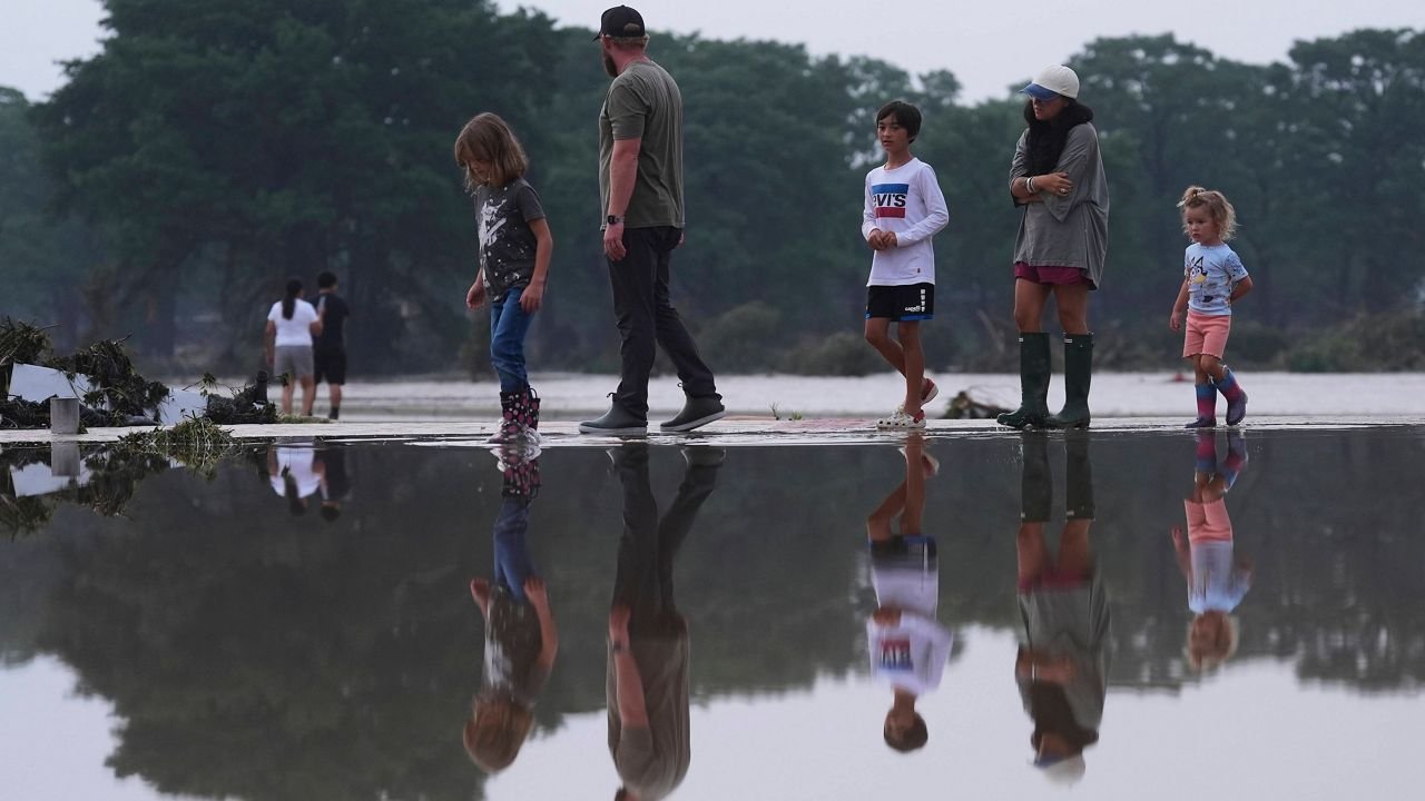
KERRVILLE, TEXAS — What began as a tranquil summer night at a children’s camp in Texas Hill Country turned into a waking nightmare as torrential rain sent a deadly wall of water surging through Kerr County, leaving 24 people dead and more than 23 young girls missing.
Emergency officials describe the flood as “catastrophic,” striking Guadalupe River communities with a ferocity that left residents, campers, and rescuers stunned.
“This happened within less than a two-hour span,” said Dalton Rice, the city manager for Kerrville, the county seat. “We couldn’t issue evacuations in time. Radar didn’t catch it. There was no warning.”
The Deadly Surge That Changed Everything
In the early hours of the morning — around 4 a.m. local time — a staggering 300 millimeters of rainfall pounded the region, causing the Guadalupe River to rise a shocking 8 meters in just 45 minutes, submerging roads, camps, and homes with terrifying speed.
The U.S. National Weather Service declared a flash flood emergency, a rare and urgent alert indicating a severe threat to life and property. The Kerr County Sheriff’s Office confirmed the death toll had reached 24 by midday and cautioned that the numbers could rise as rescue operations continued.
The scenes were grim — submerged cabins, overturned RVs, uprooted trees, and mangled playground equipment.
“I’m asking the people of Texas — do some serious praying this afternoon,” pleaded Texas Lieutenant Governor Dan Patrick at a press conference. “On-your-knees kind of praying — that we find these young girls.”
“Camp Mystic” Turned into a Camp of Terror
The most heart-wrenching aspect of the tragedy centers around Camp Mystic, a beloved 100-year-old summer camp nestled along the banks of the river and known for hosting over 700 girls each summer from all across the state.
At the time of the flood, more than 700 children were asleep in rustic cabins, with no electricity, no running water, and no cellular signals as the storm raged on.
Dozens of families have taken to Facebook and local forums, pleading for news about their daughters. Some reported receiving chilling phone calls from safety officials confirming their child had not yet been located.
“If you have not been contacted directly, your child is accounted for,” read a message sent by Camp Mystic in an email to parents — but for the 23 unaccounted-for girls, time is running out.
The Unseen Heroes: First Responders Battle Nature’s Fury
So far, 237 people have been rescued, including 167 by helicopter, many plucked from trees or rooftops surrounded by swirling floodwaters. Videos circulating on social media show Black Hawk helicopters hovering above the treetops, hoisting frightened campers to safety.
Officials confirmed 14 helicopters and 12 drones are currently being used in search and rescue operations, supported by hundreds of ground personnel.
“We are seeing unprecedented coordination between local fire departments, the U.S. Coast Guard, and FEMA,” said Kerr County Judge Rob Kelly, the top elected official in the county. “Everybody is doing everything in their power to get these kids out.”
No Time to Escape
Many victims had no time to react. Subdivisions and RV parks along the Guadalupe River were swallowed up within minutes, according to officials.
“There were campers trying to climb trees, counselors using flashlights to guide girls to higher ground — all while the power was out,” said a volunteer firefighter who requested anonymity. “It was chaos. Pure chaos.”
Camp leaders admitted that most escape routes were cut off, with roads submerged or completely washed away. Communications went down almost immediately.
“There was no cell signal, no Wi-Fi. We were blind and alone,” said a counselor in a shaken voice during a local news interview.
What Comes Next?
The disaster is not over. The National Weather Service has warned of more rainfall over the next 24 to 48 hours, putting Central Texas, including areas from San Antonio to Waco, at continued risk of flash flooding.
Lieutenant Governor Patrick issued a stern warning:
“Even light rain can trigger more flash floods. The soil is saturated. The rivers are full. One more downpour and it could all happen again.”
Residents are being urged to stay off roads, monitor emergency updates, and avoid crossing any flooded areas.
Meanwhile, families are still waiting, praying, and hoping for a miracle — a signal, a name on the list, a voice on the phone saying: “She’s alive.”

Liverpool vs Brighton, Chelsea vs Everton and More — Live Football Action as Premier League Drama Unfolds

Bryant Haines Set to Become One of College Football’s Highest-Paid Assistants After Indiana’s Dream Season

Sherrone Moore Fired and Arrested — Why Michigan Athletics Is Facing Its Biggest Culture Crisis Yet

League of Legends 2026 Swiftplay Gets a Massive Overhaul With Faster Games and Shocking Jungle Changes

Olivia Rodrigo Leaves Her Idol ‘Mind Blown’ With Stunning A Cappella Christmas Cover

1-Iran Issues Dire Warning to Israel and Defies Trump on Nukes: “We’re Ready to Strike Deep Inside”

Donald Trump’s net worth reveals the fortune behind the former US President and business mogul

Caitlin Clark Sidelined with Quad Strain, Set to Miss Two Weeks of WNBA Action

Elon Musk Breaks Ranks with Trump Over ‘Big, Beautiful’ Tax Bill

Golden Glory: Team USA Wins First Standalone Ice Hockey World Championship in 91 Years

Miss Jamaica Suffers Terrifying Fall Off Miss Universe Stage; Rushed to Hospital on Stretcher in Viral Video

Moana Live-Action Teaser Sparks Outrage as Fans Call Disney’s Move a ‘Clear Money Grab’ — What Went Wrong?

Ryan Gosling’s Project Hail Mary Trailer Stuns Fans with a Mysterious Alien Ally and a Mission That Could Save Earth

Apple delays Jessica Chastain thriller The Savant about domestic extremism after recent US violence

Avatar 3, Fire and Ash trailer reveals Jake Sully’s family facing terrifying new Na’vi enemies with deadly fire powers
-

 US News6 days ago
“She Never Made It Out…” Albany House Fire Claims Woman’s Life as Family Pleads for Help to Bring Her Home
-

 Entertainment1 week ago
“Detective, Psychologist, Anthropologist?” — Inside the Secret World of Casting Directors Behind ‘F1,’ ‘The Smashing Machine’ and ‘Marty Supreme’
-

 Entertainment1 week ago
“It Changed My Life…” Sydney Sweeney Breaks Silence on Oscar Buzz for ‘Christy’ and Why the Film’s Dark True Story Still Haunts Her
-

 Entertainment5 days ago
Samba Schutte Reveals the Surprise Cameo in Pluribus That “Nobody Saw Coming”… and Why John Cena Was Perfect for the Role
-

 Entertainment1 week ago
“A Sentence From a Country He’s Not Even In…” Jafar Panahi Hit With New Prison Term as He Prepares to Attend Gotham Awards
-

 Entertainment5 days ago
XG Star Cocona Shares a Brave Truth at 20 — “I Was Born Female, But That Label Never Represented Who I Truly Am…”
-

 Entertainment1 week ago
Legendary Guitarist Steve Cropper Dies at 84… Tributes Pour In for the Soul Icon Behind ‘Green Onions’ and ‘Soul Man’
-

 Entertainment1 week ago
‘One Battle After Another’ Stuns the Gotham Awards as Jafar Panahi Delivers Defiant Message Hours After Iran Sentencing